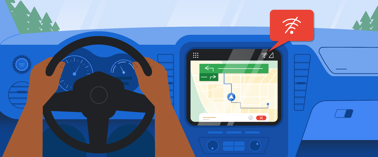
This may be a stupid question but if your phone loses its signal when you are driving then I presume that google maps won't update with the possibility of missing turn offs etc.I sold my Garmin Camper LMT D 760
Now only use Google maps on 8 in Lenovo GPS tablet .. tethered to the phone for data ..
you can download Google maps for the area you are travelling and use without data , but you don't have the excellent live traffic updates and re routing ,so I don't bother.

Navigation
Install the app
How to install the app on iOS
Follow along with the video below to see how to install our site as a web app on your home screen.
Note: This feature may not be available in some browsers.
More options
You are using an out of date browser. It may not display this or other websites correctly.
You should upgrade or use an alternative browser.
You should upgrade or use an alternative browser.
SatNav or Google Maps?
- Thread starter Helgamobil
- Start date
It's possible to download areas of google maps in advance to work offline should you loose your data connection.This may be a stupid question but if your phone loses its signal when you are driving then I presume that google maps won't update with the possibility of missing turn offs etc.
- Jan 26, 2017
- 3,923
- 13,430
- Funster No
- 47,068
- MH
- Autosleeper Inca
- Exp
- Eight Years and 28,000 Miles.
I don't think this is possible.Just been looking at this! But as far as I can see, you need something running either MAC or Windows, which I don't possess. Would be delighted if anyone knows a way to transfer S4S onto a Garmin without...
You have to download a file then install it to your satnav unit, how do you update your satnav without a PC?
scotjimland
LIFE MEMBER
I've used Google Maps on many trips abroad.. and it's never been an issue.. but if you were venturing somewhere where the mobile signal may be weak or non existent, as pointed out by ChrisL and as I said in my last post .. you can download the map for that area ...This may be a stupid question but if your phone loses its signal when you are driving then I presume that google maps won't update with the possibility of missing turn offs etc.
you can download Google maps for the area you are travelling and use without data , but you don't have the excellent live traffic updates and re routing ,so I don't bother.
I can only suggest you try Google Maps.. As I mentioned earlier, I found it so good I sold my Garmin Camper as I no longer used it ..
How to keep using Google Maps even when your phone is offline
These simple steps will help you keep using Google Maps offline when you don’t have an internet connection.
I think it needs a signal to create a new route. But it pre-stores the next leg of the route as you go. I've never had it fail due to lack of signal. It does occasionally say there's no traffic data off you have no signal for a long time. Often (if you're on WiFi?) it'll ask if you want to download the whole route when you set the destination.This may be a stupid question but if your phone loses its signal when you are driving then I presume that google maps won't update with the possibility of missing turn offs etc.
You can also download and store areas of the map. So if you do have a patchy signal, there's less data required to keep it going. And if you have an area at home, it'll slightly reduce the amount of mobile data required.
Subscribers do not see these advertisements
Wondered why it never seems to lose signal, now I know!I think it needs a signal to create a new route. But it pre-stores the next leg of the route as you go. I've never had it fail due to lack of signal. It does occasionally say there's no traffic data off you have no signal for a long time. Often (if you're on WiFi?) it'll ask if you want to download the whole route when you set the destination.
You can also download and store areas of the map. So if you do have a patchy signal, there's less data required to keep it going. And if you have an area at home, it'll slightly reduce the amount of mobile data required.
- Feb 2, 2021
- 125
- 81
- Funster No
- 79,055
- MH
- Globestar 640dk
I just bought a Garmin Camper 895 and am seriously disappointed with it's level of information and the fact that it can't seem to reroute going forward. It tries to get me to do a U turn and go a ridiculously long way backwards first. Pity google didn't let you put dimensions in. That would fix the whole problem and I'd still have £500!!!Google maps and navigation is 10 years ahead of the dedicated ones.
Street view.
Satellite view.
All Pois.
Customer Rewiews.
Free.
Fast.
I'm amazed anybody pays for a device in 2024
PS the dimensions on other units can't be trusted, they WILL stitch you up sooner or later

- Jan 26, 2017
- 3,923
- 13,430
- Funster No
- 47,068
- MH
- Autosleeper Inca
- Exp
- Eight Years and 28,000 Miles.
.
- Jan 26, 2017
- 3,923
- 13,430
- Funster No
- 47,068
- MH
- Autosleeper Inca
- Exp
- Eight Years and 28,000 Miles.
Just looking at a non toll route from Dresden to Prague travelling south of 'Pirna', and can see that there is a tunnel that is not shown on Google Maps at all, the B172n, (satellite images seem to show it still being built), but is on my Garmin Camper mapping as it is on Via Michelin maps.Google maps and navigation is 10 years ahead of the dedicated ones.
Street view.
Satellite view.
All Pois.
Customer Rewiews.
Free.
Fast.
I'm amazed anybody pays for a device in 2024
PS the dimensions on other units can't be trusted, they WILL stitch you up sooner or later
Not the first serious omission of a road I have encountered on Google Maps, so be aware it's not 100% accurate.
scotjimland
LIFE MEMBER
there isn't enough data for all roads for a reliable way of doing that accurately ...Pity google didn't let you put dimensions in.
in the UK we have four classes... M, A, B, C, and unclassified..
Google will always take the fastest route using the road classes in preference order.. ie. M. A. B. C... then unclassified if no option..
if your destination is a CL and it on an unclassified road, then it has no option but to use that road... same with any sat-nav ...
why it is important to always check the last few miles of your route using Google street view satellite view or paper map ..
.
and yes,. you could have saved £500 .. I sold mine for £100
Subscribers do not see these advertisements
- Feb 2, 2021
- 125
- 81
- Funster No
- 79,055
- MH
- Globestar 640dk
Aww, grim!there isn't enough data for all roads for a reliable way of doing that accurately ...
in the UK we have four classes... M, A, B, C, and unclassified..
Google will always take the fastest route using the road classes in preference order.. ie. M. A. B. C... then unclassified if no option..
if your destination is a CL and it on an unclassified road, then it has no option but to use that road... same with any sat-nav ...
why it is important to always check the last few miles of your route using Google street view satellite view or paper map ..
.
and yes,. you could have saved £500 .. I sold mine for £100

- May 8, 2011
- 4,382
- 58,107
- Funster No
- 16,317
- MH
- IH Tio 630 RL
- Exp
- Since April 1846 but have always camped.
I use google maps but just tried Waze. It worked fine but have read that it sucks power out of the battery.
Any app that has the screen on continuously will drain the battery. None of the satnav apps are significantly different in that regard. So plug it in while you're driving?I use google maps but just tried Waze. It worked fine but have read that it sucks power out of the battery.
- May 8, 2011
- 4,382
- 58,107
- Funster No
- 16,317
- MH
- IH Tio 630 RL
- Exp
- Since April 1846 but have always camped.
Yes but evidently waze uses much more than other apps.Any app that has the screen on continuously will drain the battery. None of the satnav apps are significantly different in that regard. So plug it in while you're driving?
I can't say I've noticed a difference. They all seem to eat about 20% battery per hour when going through wireless android auto... which I rarely test because I normally remember to plug my phone in. Why wouldn't you?Yes but evidently waze uses much more than other apps.
Subscribers do not see these advertisements
- Aug 18, 2014
- 27,704
- 171,301
- Funster No
- 32,898
- MH
- Transit PVC
- Exp
- 16 years since restarting
I've never updated one in my life?how do you update your satnav without a PC?

I always assume nothing is.Just looking at a non toll route from Dresden to Prague travelling south of 'Pirna', and can see that there is a tunnel that is not shown on Google Maps at all, the B172n, (satellite images seem to show it still being built), but is on my Garmin Camper mapping as it is on Via Michelin maps.
Not the first serious omission of a road I have encountered on Google Maps, so be aware it's not 100% accurate.
All mine plugged in permanently. sat -nav, 2x front cameras ,2 x rear cameras, head unit ,So plug it in while you're driving?
yes my wife doesn't?which I rarely test because I normally remember to plug my phone in. Why wouldn't you?
 plugs in when flat .not uncommon to have a phone, note book, tablets x 2 another phone for audio books, all being charged at once.
 So its either Google Maps or Waze for me.
- Dec 19, 2022
- 137
- 122
- Funster No
- 92,960
- MH
- Lunar Fivestar
- Exp
- Motorhoming since 2011 - now returning after a long break!
Thank you for all the advice - still thinking of returning to SatNav (not sure which one) to save phone data use when abroad. Several hours/days driving is going to soak up a lot of our Gbs.
I am late into this thread but have you tried herewego maps free download,no ads downloaded maps and then works completely offline.Thank you for all the advice - still thinking of returning to SatNav (not sure which one) to save phone data use when abroad. Several hours/days driving is going to soak up a lot of our Gbs.
Google Maps uses about 5MB per hour of driving. If you drive 8 hours a day for a month, you'd use about 1GB. Compared to streaming video, it's nothing.Thank you for all the advice - still thinking of returning to SatNav (not sure which one) to save phone data use when abroad. Several hours/days driving is going to soak up a lot of our Gbs.
Subscribers do not see these advertisements
- Dec 19, 2022
- 137
- 122
- Funster No
- 92,960
- MH
- Lunar Fivestar
- Exp
- Motorhoming since 2011 - now returning after a long break!
Thank you for that response - I had been researching and found a figure (more than once) of 40Mbs of data per hour - and several other figures being flung out there. Hard to know which is accurate!Google Maps uses about 5MB per hour of driving. If you drive 8 hours a day for a month, you'd use about 1GB. Compared to streaming video, it's nothing.
scotjimland
LIFE MEMBER
you can download Google maps for the area you are going ..Thank you for that response - I had been researching and found a figure (more than once) of 40Mbs of data per hour - and several other figures being flung out there. Hard to know which is accurate!
Download areas & navigate offline - Android - Google Maps Help
You can save an area from Google Maps to your phone or tablet and use it when you're offline. Tip: You’re unable to download offline maps in some countries or regio
support.google.com
Technically, 40Mb would be 40 megabits, which is 5MB or 5 megabytes...Thank you for that response - I had been researching and found a figure (more than once) of 40Mbs of data per hour - and several other figures being flung out there. Hard to know which is accurate!
Even if it was 40MB/hour, 40MB is about a minute of HD video, or about 20 average web pages.
You can reduce the amount of data Google Maps uses by storing the maps for offline use. I think it still needs some data to plan new routes though. And it obviously needs data to get real time traffic information.
- Oct 21, 2019
- 323
- 358
- Funster No
- 65,912
- MH
- Carthago C-Tourer
- Exp
- Begun travelling the road in our first van in 2013
Hi Guigsy, in response to your above quoted reply, how would you go about setting that up? We have Apple Carplay in our moho, through a Pioneer head unit. I can use Apple Maps etc which show up on the Pioneer screen, but the size is a bit limiting and it's obviously flat on to the dash which makes it awkward to see at times. Would a larger tablet (ipad) mirror up the information I wonder? Keen to hear how you would set this up.If you had a head unit with Apple Carplay, you could have a large display on your dashboard.
You could just use an iPad instead, then you wouldn't need AirPlay. I installed a 9" Sony head unit, which makes it pretty easy to follow with a quick glance.Hi Guigsy, in response to your above quoted reply, how would you go about setting that up? We have Apple Carplay in our moho, through a Pioneer head unit. I can use Apple Maps etc which show up on the Pioneer screen, but the size is a bit limiting and it's obviously flat on to the dash which makes it awkward to see at times. Would a larger tablet (ipad) mirror up the information I wonder? Keen to hear how you would set this up.
Subscribers do not see these advertisements
- Oct 21, 2019
- 323
- 358
- Funster No
- 65,912
- MH
- Carthago C-Tourer
- Exp
- Begun travelling the road in our first van in 2013
ahh, but none of our old ipads have inbuilt GPS, so it still needs to be tethered to an iPhone to get the positional data across.You could just use an iPad instead, then you wouldn't need AirPlay. I installed a 9" Sony head unit, which makes it pretty easy to follow with a quick glance.
- May 24, 2022
- 62
- 100
- Funster No
- 88,865
- MH
- Converted VW Crafter
I've always used waze or google but got stuck once near Oxford.
I can't remember who but somebody on here told me about Magic Earth It has a setting for Van where you can set the dimensions etc
So when you search somewhere, you select the Van picture and it should choose the route that takes that into consideration.
And it's free.
I've only used it once so far


I can't remember who but somebody on here told me about Magic Earth It has a setting for Van where you can set the dimensions etc
So when you search somewhere, you select the Van picture and it should choose the route that takes that into consideration.
And it's free.
I've only used it once so far
Someone ought to do a standardised test on these. I.e. get it to give you a route though a series of known problem locations. And the effect of changing your vehicle size. It would be good to confirm inputting your dimensions isn't just a placebo effect.