I have tried the journals a couple of times with retrospective training so thought I would give it a live go with our 28 day trip to the Languedoc which if youre the first one to read this, starts tonight. But first I have to finish this night shift and then come in tonight before setting off described later.
For those of you who dont know, we are 57 and 55 at time of leaving, relatively fit in a previous life, are not cyclists, yet enjoy cycling Ebikes with 400 watts of Bosch power on decent Haibikes that we have had for 3 years and we like the flat cycling. We enjoy wine, beer and the wife likes whisky. We are quite tight with our finances. I am still employed full time, but they owe me shed loads of annual leave for the next 3 years.
Our travel this time will be with the Ebikes in the garage and we wont be taking the Suzuki Address 110cc of our Roller Team 685 automatic which is 18 months old and we have had from new. A fridge issue last year was an inconvenience (basically we didnt have one) but all that is resolved by putting in the missing baffle so we have 370 watts of solar, 200 ah of lithium and an inverter, Gaslow tanks, TomTom and 750 quids worth of Remis blinds (excuse me while I cry because my lithium was cheaper)
Planning for this has been done in the form of a map. I have created the map as an aide memoire and includes all the aires (that I can find) of potential use to us, France Passion, Beaux Villages, planned flat cycling and POIs which we may go to. You will note all the yellow beach umbrella icons which have been taken from the 2nd edition of Wild Swimming in France which is an excellent resource book. The blue lines are the cycle routes we have an eye on (disused railway lines). I doubt we will get to go on the canal du midi too far. The black icons are waterfalls or walks up gorges which have waterfalls so you probably have an expectation of photos incoming.

What you wont see is photos of meals that have been bought at a restaurant and guessing how much they cost. A meal did occur on our 25th Wedding anniversary but not before then or since and we return just prior to our 33rd Anniversary (providing she can put up with me)
At the bottom of the map you will see a series of orange steam trains which are the train stations of the little yellow train which we really hope to get on.
We have been to the area before and did 2 of the hot natural (free) springs but have located 2 more now, but their precise location is kept a secret, but sufficient enough clues around the internet have given me confidence I know the exact place and how to get there, but we ll see how that confidence gets on.
We are not likely to get everything done, but the certs are the train, the gorges de caranca, the hot springs, the passa pais cycle route (top one) and the suspension bridge at Mazamet. Other certs will include wine, vineyards, vino, Red, White and Rose at a guess. (Maybe some vulture feeding)
I have pre written this (but hopefully not published it yet) and we will leave in the early evening of Saturday 22nd and the wife will stay overnight in the car park at work whilst I do a12 9 hour night shift. TOIL means I can leave at 0330 hrs to go to Newhaven (about 90 minutes) in order to catch the 0630 hrs and land in Dieppe about Midday Frog time, hopefully having had a kip on the ferry and aim to get to La Loire or past it. Not overly sure which way we are going down yet but we will probably return the other way.
Hopefully I will post each day.

(Stock photo) (Yes Gravelines)
The map above is the one I use for planning, normallyat work on my laptop at home but just prior to kick off a query came up on the forum about mapy.cz which we use on the bikes as it is free, no need for wifi, and has all the cycle routes on it.
To counter stopping at every junction and looking at the phone each time I got a Garmin to go on the pushbikes where I load up a route and through the magic of internet and bluetooth that route appears on the bikes Garmin.
But today this query came up and I went onto the mapy.cz actual website and perused about a bit, like you do, and noted that I can create a map on there. 10 minutes later and now all my POIs created on google are on mapy.cz so we can now look for them whilst cycling on the same map we would use.
When I get chance I will see if I can put those POIs onto the Garmin as well as that will help with creating cycle routes.
It looks something like this on the website

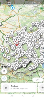
and something like this on the app

and when zoomed in you can see the pink dotted cycle routes with a couple of swimming points (POIs) whereas the red ones are walking routes
Anyway, all things being equal, first update from after the ferry journey on Sunday night or Monday morning.
For those of you who dont know, we are 57 and 55 at time of leaving, relatively fit in a previous life, are not cyclists, yet enjoy cycling Ebikes with 400 watts of Bosch power on decent Haibikes that we have had for 3 years and we like the flat cycling. We enjoy wine, beer and the wife likes whisky. We are quite tight with our finances. I am still employed full time, but they owe me shed loads of annual leave for the next 3 years.
Our travel this time will be with the Ebikes in the garage and we wont be taking the Suzuki Address 110cc of our Roller Team 685 automatic which is 18 months old and we have had from new. A fridge issue last year was an inconvenience (basically we didnt have one) but all that is resolved by putting in the missing baffle so we have 370 watts of solar, 200 ah of lithium and an inverter, Gaslow tanks, TomTom and 750 quids worth of Remis blinds (excuse me while I cry because my lithium was cheaper)
Planning for this has been done in the form of a map. I have created the map as an aide memoire and includes all the aires (that I can find) of potential use to us, France Passion, Beaux Villages, planned flat cycling and POIs which we may go to. You will note all the yellow beach umbrella icons which have been taken from the 2nd edition of Wild Swimming in France which is an excellent resource book. The blue lines are the cycle routes we have an eye on (disused railway lines). I doubt we will get to go on the canal du midi too far. The black icons are waterfalls or walks up gorges which have waterfalls so you probably have an expectation of photos incoming.
What you wont see is photos of meals that have been bought at a restaurant and guessing how much they cost. A meal did occur on our 25th Wedding anniversary but not before then or since and we return just prior to our 33rd Anniversary (providing she can put up with me)
At the bottom of the map you will see a series of orange steam trains which are the train stations of the little yellow train which we really hope to get on.
We have been to the area before and did 2 of the hot natural (free) springs but have located 2 more now, but their precise location is kept a secret, but sufficient enough clues around the internet have given me confidence I know the exact place and how to get there, but we ll see how that confidence gets on.
We are not likely to get everything done, but the certs are the train, the gorges de caranca, the hot springs, the passa pais cycle route (top one) and the suspension bridge at Mazamet. Other certs will include wine, vineyards, vino, Red, White and Rose at a guess. (Maybe some vulture feeding)
I have pre written this (but hopefully not published it yet) and we will leave in the early evening of Saturday 22nd and the wife will stay overnight in the car park at work whilst I do a
Hopefully I will post each day.
(Stock photo) (Yes Gravelines)
The map above is the one I use for planning, normally
To counter stopping at every junction and looking at the phone each time I got a Garmin to go on the pushbikes where I load up a route and through the magic of internet and bluetooth that route appears on the bikes Garmin.
But today this query came up and I went onto the mapy.cz actual website and perused about a bit, like you do, and noted that I can create a map on there. 10 minutes later and now all my POIs created on google are on mapy.cz so we can now look for them whilst cycling on the same map we would use.
When I get chance I will see if I can put those POIs onto the Garmin as well as that will help with creating cycle routes.
It looks something like this on the website
and something like this on the app
and when zoomed in you can see the pink dotted cycle routes with a couple of swimming points (POIs) whereas the red ones are walking routes
Anyway, all things being equal, first update from after the ferry journey on Sunday night or Monday morning.